
Watch Video Tour
WHAT OUR GUESTS SAY
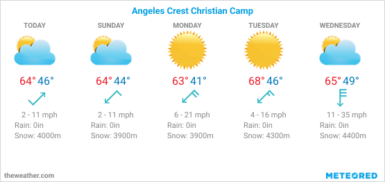
WEATHER
Angeles Crest Christian Camp is in the middle of the Angeles National Forest at an elevation of 6,000 feet so the weather can change dramatically depending on the time of year. Typically, during the summer season (June through September) it can be hot and dry with temperatures in the 80 to 90 degree range. In the winter season (December through March) we often have low temperatures and even snow at camp depending on the weather pattern.
Five-Day Forecast
A few tips…
Dress – The best way to dress for a visit to Angeles Crest Christian Camp is to bring layers regardless of the time of year.
· For summer time you can bring shorts for warm weather during the day and pants for the evening. You’ll need a coat/sweatshirt for the cooler evening weather. Closed toe shoes (tennis shoes) are best for comfort and safety.
· For winter time you’ll need to be layered. It’s recommended that you bring pants, a shirt, and a warm sweatshirt and/or a coat. During the winter time we do have snow and the temperature can drop below freezing during the day and especially at night. Boots are recommended during the winter time in case of snow.
Sunscreen – Since the camp is located at 6000 feet elevation, there is high exposure to the sun’s rays. Make sure you bring a hat and sunscreen for protection from the sun during the day.
Water Bottle – During the summer it can be especially warm and dry so it is a great idea to bring a water bottle so you can remain hydrated during your stay at camp. Even during the winter time the air is dry so it’s a good idea to bring a water bottle with you as well.

